
By James Daniell, Jian Vun, Andres Maglione
Imagine losing everything you have built over years in a single day. This was the reality for many families in Vanuatu when, in March 2015, Tropical Cyclone (TC) Pam struck Port Vila. With extreme winds reported around 250 km/h and destructive storm surges, TC Pam devastated urban settlements and damaged critical infrastructure. The economic losses and damages were equivalent to roughly 64% of Vanuatu’s GDP.
The Pacific is among the world’s most exposed regions to natural and climate-related hazards—and those risks are expected to intensify with climate change. Risk is also increasing because of the pace and pattern of urban growth. Urban and peri-urban areas are expanding rapidly, often into low-lying coastal zones, flood-prone land, or other hazard hotspots.
When disasters strike, impacts are compounded by limited capacity to recover quickly: there is a need for more proactive contingency planning, established business continuity measures, and resilience-building initiatives targeting the urban sector.
The challenge of mapping risk
This is why understanding hazard exposure matters. Without a clear picture of who and what is at risk today and in the future, it is difficult to prioritize investments, guide safer urban expansion, and reduce future losses. This is exactly what the Spotlight: Mapping Risk, Building Resilience – Exposure Analysis of Pacific Urban Areas sets out to answer. The report, prepared by the Disaster Analytics thematic area of the Global Facility for Disaster Reduction and Recovery, presents risk modelling and scientific analysis to quantify the exposure of people and building assets across 38 urban areas in 10 Pacific Island Countries.
The methodology combined local and global datasets on population and building stock, overlaying them with hazard maps to show where people and assets sit in hazard-prone areas. Hazards are assessed were: earthquakes; flooding (coastal, pluvial, and fluvial); and tropical cyclone winds. The analysis provides a consistent baseline to understand how exposure may shift towards 2050 as cities expand and risks intensify.
What results show
The results of the analysis are clear: by 2050, hazard exposure will grow sharply, largely driven by rapid population growth in hazard-prone areas. This creates a massive "hidden bill" that will cost governments and communities in the years to come.
To put the scale of this financial threat into perspective, the value of building assets exposed to earthquakes and cyclones alone is expected to leap from $33.5 billion in 2024 to $58.4 billion by 2050: this is nearly 9 times the size of Fiji’s economy.
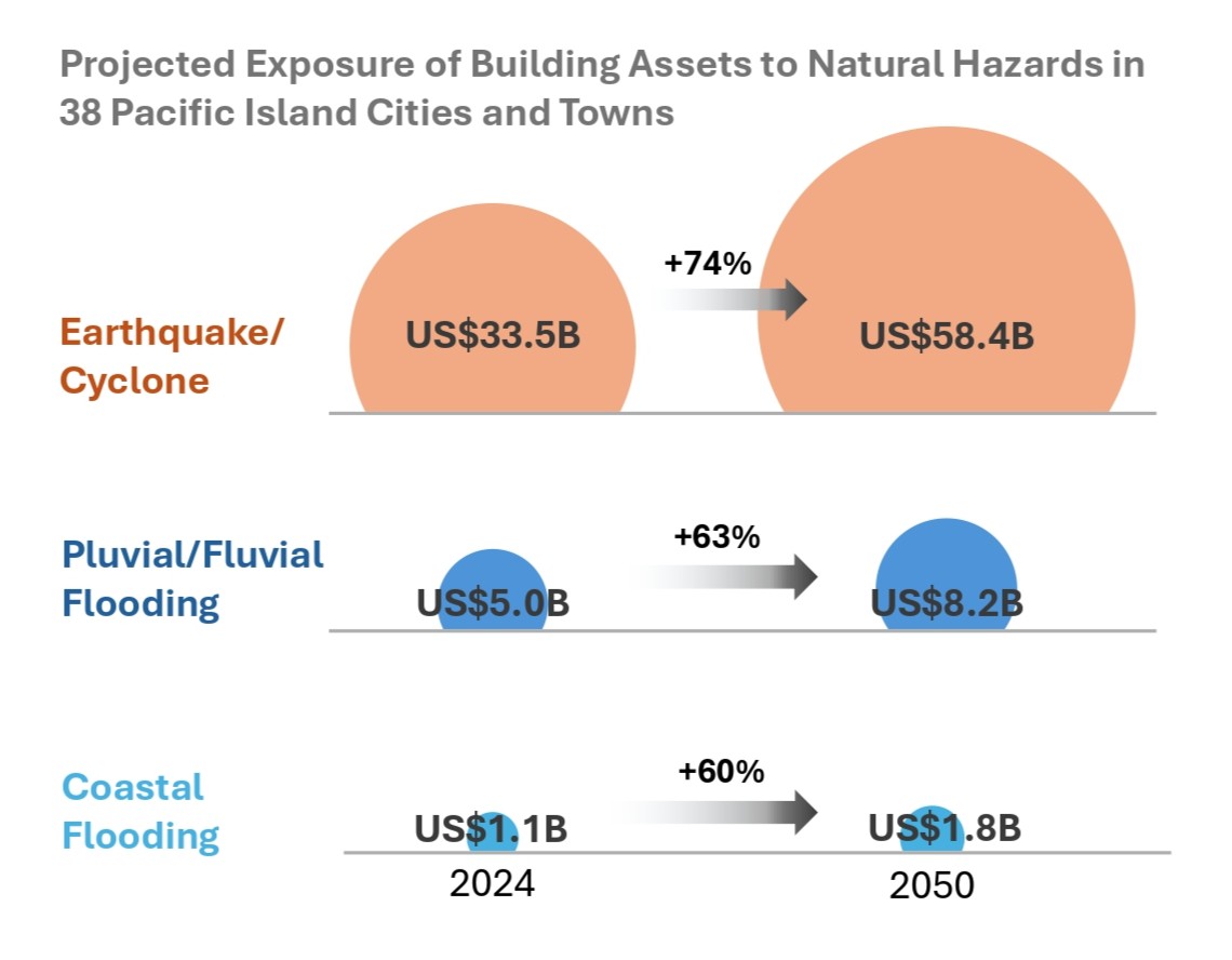
Projected exposure to natural hazards is expected to increase significantly across 38 Pacific Island cities, with earthquake and cyclone exposure rising by 74%, pluvial and fluvial flooding by 63%, and coastal flooding by 60% by 2050. Adapted from: Mapping Risk, Building Resilience – Exposure Analysis of Pacific Urban Areas. World Bank, 2026.
Not all cities feel the weight of these risks in the same way. Port Vila and Luganville (Vanuatu), Honiara (Solomon Islands), and Nadi and Suva (Fiji) consistently rank highly across hazard types. Honiara stands out for exceptionally high exposure to flooding and earthquakes.
Other cities face a more existential threat. Due to their low elevations and narrow land, atoll capitals—South Tarawa (Kiribati), Majuro (Marshall Islands), and Funafuti (Tuvalu)—face acute exposure to coastal flood hazards. Across all 38 urban areas, the number of people exposed to coastal flooding is projected to nearly double, from 20,025 in 2024 to 39,015 in 2050.
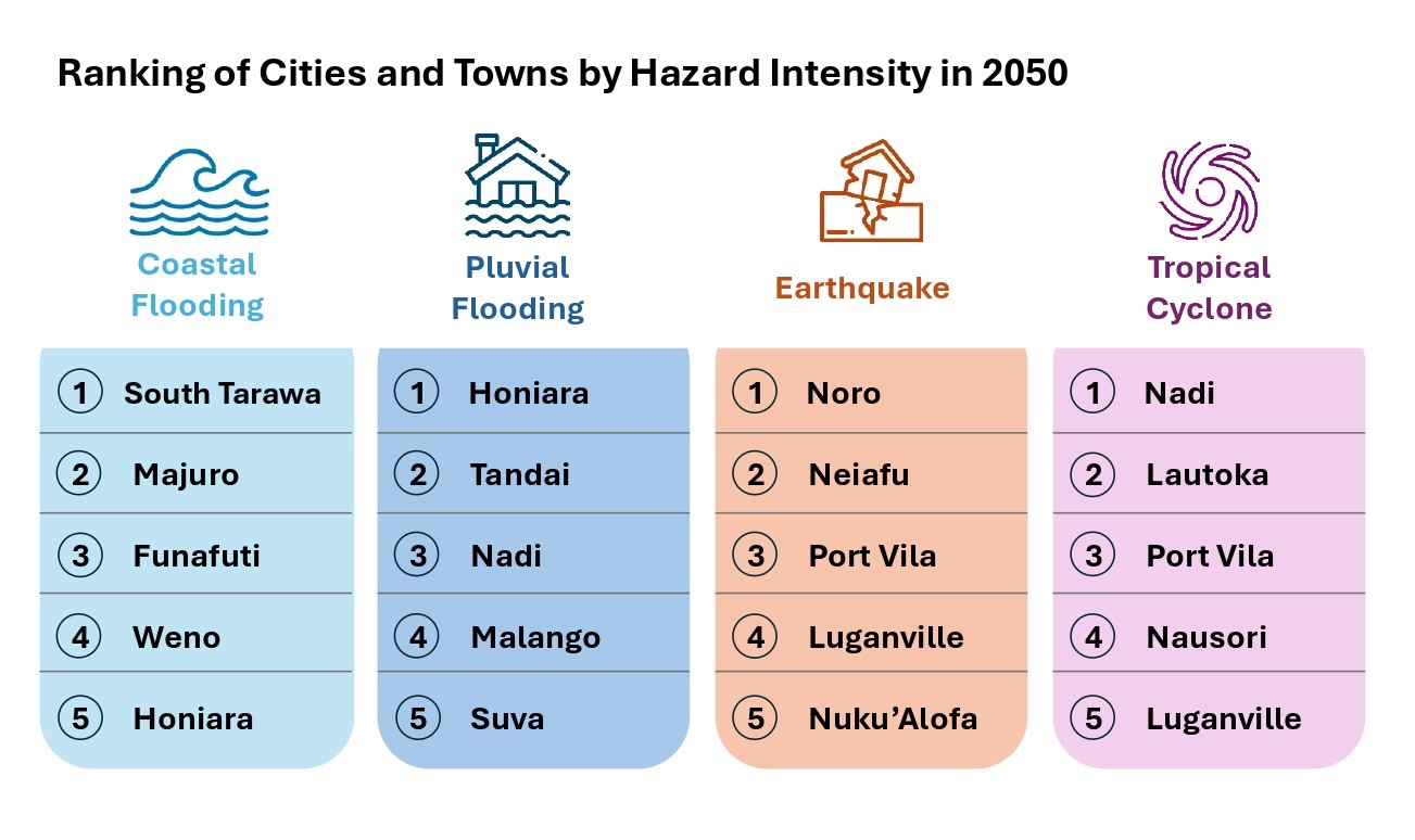
Cities are exposed to hazards in different ways. This ranking reflects relative hazard intensity in 2050. Adapted from: Mapping Risk, Building Resilience – Exposure Analysis of Pacific Urban Areas. World Bank, 2026.
Beyond coastal threats, Pacific nations face a rapidly growing river and pluvial flooding risk. The number of people exposed will double from 159,000 in 2024 to 360,000 by 2050.
The bottom line: what policymakers can do
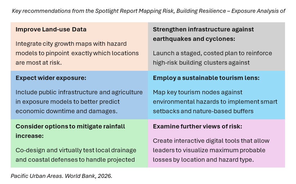
Practical steps for governments and cities working to reduce exposure and future disaster losses are highlighted in the table below.
In the Pacific, the cost of inaction is rising as fast as sea levels. The roadmap to resilience is clear; now, we must find the collective will to follow it and build a safer, more sustainable urban future for all.
The Livable Pacific Cities and Towns report was made possible due to the generous financial support from the European Union, in the framework of the Africa Caribbean Pacific – European Union (Disaster Risk Management Programme, managed by the Global Facility for Disaster Reduction and Recovery (GFDRR).
Inputs to this blog were also made by Rashmin Gunasekera, Jessica Schmidt, and Kerri Cox.