
Guyana’s Conservancy Adaptation Project
In January 2005, extreme and prolonged rainfall caused widespread flooding in Guyana with flood levels reaching over one and a half meters in some coastal villages. Approximately 290,000 people (39% of Guyana’s population) were affected, including the capital city Georgetown, with many areas remaining inundated for up to three weeks. The 2005 flood disrupted livelihoods and resulted in long-lasting economic impacts that are estimated to amount to US$465 million (59% of Guyana’s GDP). A large proportion of the losses were due to damages to thousands of acres of rice and other sources of economic activities that are concentrated in the low-lying coastal plains in Regions 4 and 5, the country’s most fertile agricultural land.

The 2005 deluge exposed structural vulnerabilities in the flood mitigation infrastructure; however, even less intense rainfall often causes flooding along the coast. As a result, Guyana’s Ministry of Agriculture collaborated with the World Bank and other international development agencies to initiate the US$3.8 million Conservancy Adaptation Project (CAP). The goal of the CAP is to help Guyana adapt to climate change by reducing the vulnerability of its coastal areas to flooding. It is a flagship project for Guyana and the Caribbean in applying modern technology to support a long-term strategy to reduce flood risk.
To learn more about the challenge, interventions and outcomes of this flood prevention project in Guyana, click here.
Utilizing Light Detection and Ranging (LiDAR) technology to tackle flooding in Guyana
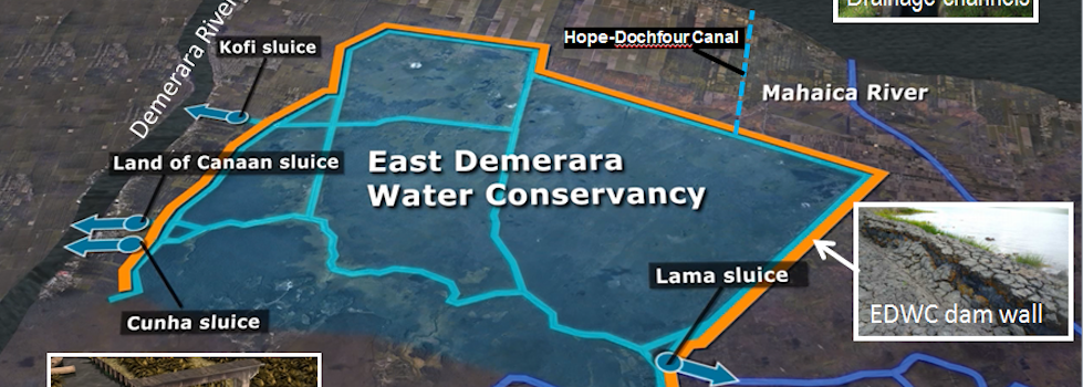
One of the main goals of the Conservancy Adaptation Project (CAP) was to strengthen the conservancy and coastal drainage systems vital for protecting the country’s key economic and populous regions. To accomplish this, the government worked closely with the World Bank team to: conduct several pre-investment studies and collect data for subsequent engineering designs; implement targeted investments in conservancy and drainage infrastructure; and build capacity within government agencies to assess and maintain crucial data and infrastructure. Throughout the lifespan of the project, the public was kept abreast of progress and development through national awareness campaigns and communications, including video animations aimed at conveying the necessity of the project and its benefits and a booklet explaining the technical aspects of the project. These communications activities were funded through a grant provided by the Africa, Caribbean and Pacific – European Union (ACP-EU) group that is managed by GFDRR. (Click here to view a video animation of the CAP)
One workshop provided to government officials aimed to strengthen and build capacity in the use of Light Detection and Ranging (LiDAR) technology in aerial surveying to produce high-resolution maps. These maps capture the flow of water over the area’s relatively flat terrain and provide detailed, high-resolution aerial ortho-photography useful in analyzing land-cover.
What’s next in Guyana’s flood mitigation efforts?
The data generated through the CAP’s pre-investment studies are being utilized for a variety of purposes. For example, the Digitial Elevation Model (DEM) produced by the project can be used as a basis for further modeling studies, 3D building-modeling, further climate change impact studies and visualizations for land-use planning and agricultural production, to name a few. There is also significant government interest in developing a data-storage and data-sharing platform to make LiDAR data easily available to government agencies and other interested organizations.
The studies conducted through the CAP also resulted in a US$123 million package of pre-designed infrastructure and nonstructural investments that will contribute significantly to flood risk management. These investments include rehabilitation of key drainage relief channels and improved conveyance within the conservancy. Follow-up investments will lead to increased capacity to manage water levels in the conservancy and lessen the area’s vulnerability to extreme climate events.
One workshop provided to government officials aimed to strengthen and build capacity in the use of Light Detection and Ranging (LiDAR) technology in aerial surveying to produce high-resolution maps. These maps capture the flow of water over the area’s relatively flat terrain and provide detailed, high-resolution aerial ortho-photography useful in analyzing land-cover. Click here to view LiDAR video tutorials.
|
Related CAP Brochure |
Related News |
|
|
