
This page in: French
Urban growth is booming in Africa. These rapidly-expanding cities are among the world's most vulnerable to the effects of climate change; many of Africa’s poorest neighborhoods are located on exposed river banks, low-lying areas or along eroding coastal shores.
With map data, local governments can know who and what are at risk and better plan and invest to protect their populations. But too often, Africa’s cities face a vast “digital map gap.” Outdated information, restricted access to data, and incomplete datasets all limit the abilities of African urban planners to prepare for and manage disaster risk.
Taking data into their own hands
What if cities could fill in the data gaps; enrolling and training students and citizens, rapidly collecting local data need to reduce risks? As technology becomes both more advanced and more accessible, ordinary citizens can learn how to use phones, cameras, drones and other tech to better identify the needs of their cities. In one year and 12 cities, the Open Cities Africa program has trained more than 500 residents, university students, and civil servants to gather data on risk. These digital cartographers have mapped more than 500,000 buildings, roads, markets, schools, hospitals, parks, canals, and other features onto OpenStreetMap, a free and collaborative map of the world.
Open Cities Africa has trained more than 500 digital cartographers and mapped more than 500,000 buildings, roads, schools, hospitals, markets, parks, canals and other features onto OpenStreetMap.
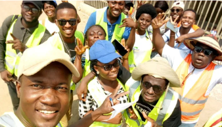
The Open Cities Accra mapping team begins their field data collection. Open Cities projects train residents, students and others how to identify vulnerable infrastructure with digital technologies, like drones and mobile phone applications. (Photo Credit: Stephen Donkor)
These map features are equipping local governments to establish the flood risk zones for hundreds of thousands of homes and expand stormwater canals into the pockets of a city in desperate need of drainage. They are also helping leaders to determine where to plant natural vegetation to reduce erosion and mudslides, and identify where to relocate households before rising seas reach their walls.
Citizen engagement is changing the way African cities prepare for disaster risks. Open Cities Africa projects have incorporated input from community members of all ages through guided focus groups and street surveys. This feedback is then incorporated into the team’s data tools or products that are ultimately used by local government leaders.
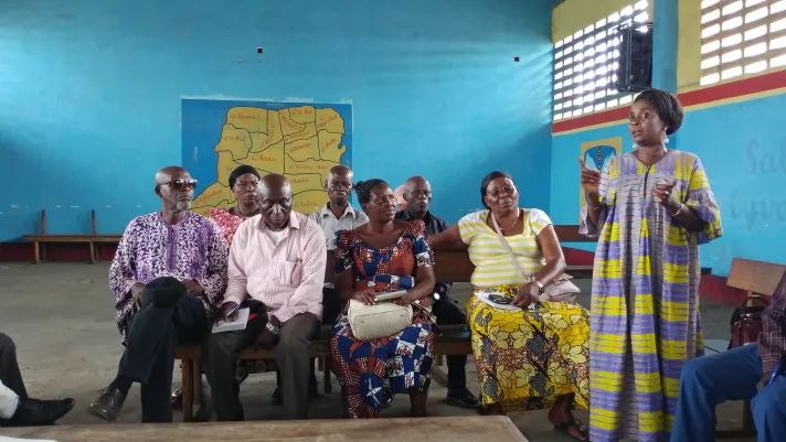
President of Delapaix neighborhood Ms. Pay Pay describes flooding issues at a community engagement event in Kinshasa, Democratic Republic of Congo. (Photo Credit: OSFAC)
A local and collaborative approach to risk mapping: Learning from Africa
With the challenges posed by climate change only rising, so will the timeliness and value of Open Cities Africa. Through an inclusive regional training program, participants ranging from young professionals to senior government leaders develop the necessary skills and capacity to continue collecting and maintaining disaster risk data to meet future needs well beyond the life of the project. These workshop delegates then go on to train the next generation of mappers in their home cities, including university students and residents themselves.
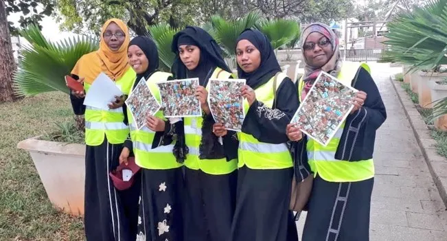
In Zanzibar, twenty former university students and several government staff and community representatives from each ward (“shehia”) were trained and participated in mobile and GPS data collection. (Photo Credit: Mohamed Kassim)
The collaborative approach of Open Cities Africa is its greatest source of success. Governments and local universities can take ownership of, update and use data that might otherwise have been made obsolete in storage. And the direct collaborative workflow allows co-created data to feed directly into urban planning policies.
- In Pointe-Noire and Brazzaville, Republic of Congo the local governments are already using data collected by neighborhood leaders, local government, students, experts, and the World Bank to implement urban upgrading.
- In Monrovia, Liberia, where flooding has brought damage to streets and sanitation systems, Open Cities maps are now being used to improve connectivity and locate garbage collection points in densely packed neighborhoods.
- For government leaders in Ngaoundéré, Cameroon, who had been working with paper and often outdated maps, georeferenced data has become a valuable resource for rapid planning.
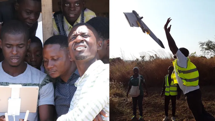
Drone technology is not only a source of high-resolution imagery for cities; open field launches act as an important community learning event for youth. (Photo Credit: ACAGER/Simon Petnga Nyamen; iLab Liberia)
Harnessing technologies for new possibilities
Wherever possible, Open Cities Africa uses new technologies to bring the latest innovations and their benefits to citizens. Drone imagery capture, is becoming a staple of community mapping. In Niamey, Niger, a partnership with a local startup led to the use of drone aerial images and an assets database to model flood risk and develop early warning systems. Other innovative approaches include the use of mobile phones and 360-degree cameras. Open Cities Africa is also piloting the use of machine learning algorithms to accelerate mapping and data collection. Through the combination of local skills and participation with advanced digital image processing, we are accelerating the rate by which government leaders can understand the built environment to address the challenges posed by climate change faster.
As urbanization and the number of people vulnerable to the effects of climate change are rising at alarming rates, it is easy to feel daunted by the challenge of disaster risk management in Africa. But witnessing the enthusiasm, technical expertise and collaborative nature of the Open Cities Africa cohort inspires great optimism. Teams from these 12 cities are setting an example for how African governments can benefit from approaches that: encourage contributions from a variety of technical backgrounds, value the feedback generated through citizen engagement, and incorporate lessons learned from counterparts in the region. They are using the latest technological innovations to create resources that can be used not just by government leaders, but also by local community members to better understand their climate vulnerabilities.
Make a Difference: Experience Open Cities Africa
Experience the energy and dynamism of the Open Cities Africa cohort and the broader OpenStreetMap Africa community via the Open Cities Summit, part of the Understanding Risk Conference for Central and West Africa, and get involved in Africa’s transformation.
Read more about Open Cities projects
- How participatory mapping can make Brazzaville’s poor neighborhoods safer
- Capturing an archipelago: Open Cities Zanzibar
- Uganda Open Mapping for Resilience completes Ggaba Parish pilot
- À Saint-Louis, Sénégal, open source et cartographie libre pour s’adapter à la montée des eaux
- Kinshasa en lutte contre les inondations grâce aux données libres d’accès
- A Antananarivo, la cartographie libre comme outil de gestion collective des Fokontany
- Leveraging OpenStreetMap to improve disaster risk management in the Seychelles
- Au Cameroun, la cartographie libre pour aider Ngaoundéré à s’adapter au changement climatique
- My experience as a student mapper for Open Cities Accra
- Tackling coastal flooding in Monrovia slums: understanding through partnerships, one community at a time
- City planning and community mapping: gathering people and data in Pointe-Noire, Republic of Congo
- Understanding Niamey’s flood risk through open source mapping, drones, and modeling
- Learn more about Open Cities Africa or check out project videos from cities around Africa.
Open Cities Africa is financed by the EU-funded ACP-EU Africa Disaster Risk Financing and Natural Disaster Risk Reduction Programs, and by the WMO’s CREWS initiative and the World Bank and GFDRR’s CityCORE initiative.