
Wired Magazine, a leading international magazine on technology and innovation, announced that a GFDRR-supported project, InaSAFE, was awarded one of the top 10 “open-source rookies of the year” alongside software developed by Microsoft, Twitter and Yahoo!. This recognition credits not only technical merits of the software and commitment to open-source but also highlights the exemplary multi-institutional collaborative development of InaSAFE that has taken place over the last two years. InaSAFE is a product of GFDRR’s Open Data for Resilience Initiative (OpenDRI) in partnership with the World Bank's East Asia and Pacific Disaster Risk Management team, the Australian Government (AusAID) through the Australia-Indonesia Facility for Disaster Reduction (AIFDR) and the Indonesian National Disaster Management Agency (BNBP).
InaSAFE - a tool that measures the impacts of disasters - was created and launched in East Asia with multiple partners, the award-winning software called the “Indonesia Scenario Assessment for Emergencies” aka InaSAFE is a free software that anyone can use to produce realistic natural hazard impact scenarios for better planning, preparedness and response activities. The disaster risk reduction and recovery GIS tool designed to help prepare countries against impacts of floods, earthquakes, and tsunamis enables governments, civil society organizations, and other entities to make evacuation plans and other disaster preparations; ultimately protecting communities and building a safer world.
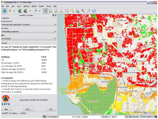
How does it work?
InaSAFE represents a new way of fighting poverty. The open-source approach is community-based that lives the beliefs that openness, innovation, and opportunity are key to project sustainability and success. Moreover, this participatory development produces a deep sense of ownership and commitment to creating resilient communities.
“(InaSAFE) is very beneficial for all of us. It’s a good example of our partnership.”
-- Dr Susilo Bambang Yudhoyono, President of Indonesia
InaSAFE provides a simple but rigorous method to combine data from scientists, local governments and communities to model the potential impacts of future disaster events. The uniqueness of InaSAFE, now being used by countries all around the globe, is that it is able to determine detailed sectoral impacts from disasters. For example, the tool can estimate the number of schools and students that would be affected by a tsunami in Maumere, Indonesia, if it happened during school hours. Futhermore, the software has been given special attention by Indonesian President Susilo Bambang Yudhoyono during the AMCDRR in Jakarta in 2012
“In the case of a flood, InaSAFE can help communities understand affected areas, how many people will need to be evacuated and sheltered, school and road closures and hospitals still able to take patients.”
-- Abhas Jha, Disaster Risk Management Coordinator for East Asia and the Pacific, World Bank
InaSAFE Partnerships and Way Forward
We are proud of the team who has been a part of the partnership to make this happen - led by the Indonesian National Disaster Management Agency (BNBP) with support from the Australian Government (AusAID) through the Australia-Indonesia Facility for Disaster Reduction (AIFDR), World Bank, and the Global Facility for Disaster Reduction and Recovery (GFDRR) Labs team . Continuing to work together and scale up, InaSAFE has the potential to save lives, better protect vulnerable people such as the young, the elderly and the disabled; making villages, towns and cities all around the world more resilient to natural disasters.
Content and images courtesy of the GFDRR Labs team, Ariel Nunez Gomez and Christina Irene. For more inforrmation, please click here or contact Christina Irene at cirene@worldbank.org.