
Highlights
- Exactly 40 years ago, the Great Thessaloniki Earthquake claimed 50 lives and damaged one-quarter of the city’s buildings.
- Although the city has recovered, its vulnerability to natural hazards remains high.
- Today, Thessaloniki is building its resilience to natural disasters through key partnerships.
Thessaloniki – Greece’s second largest city dating back nearly 2,300 years – has overcome several major catastrophes, including in the last century. The Great Thessaloniki Fire of 1917 destroyed two-thirds of the city and left more than 70,000 inhabitants homeless. And exactly 40 years ago, the 1978 Thessaloniki Earthquake damaged one-quarter of the city’s buildings, claimed 50 lives, and brought about economic damages in excess of US$ 250 million.
Fortunately, the city recovered from these and other natural disasters to become one of Greece’s key cultural, educational and economic centers, home to highly-recognized universities and research centers, and with one of the largest ports in the Aegean Sea.
Nevertheless, the city’s vulnerability to natural hazards remains high, compounded by ongoing challenges such as high unemployment and insufficient opportunities for young people, all of which weakens the city’s economic potential and overall quality of life.
In light of these challenges, the Municipality of Thessaloniki – a member of the 100 Resilient Cities initiative – developed its own Resilience Strategy, which then led to key partnerships with the Global Facility for Disaster Reduction and Recovery (GFDRR), the Rockefeller Foundation, and the World Bank.
These partnerships support critical efforts to address aging infrastructure, rebuild trust between communities and public authorities, encourage youth participation in civic duties, create adequate contingency response plans, and maximize preparedness for earthquakes and other natural disasters.
But how can decision-makers and citizens develop forward-looking solutions and practical measures as part of Thessaloniki’s Resilience Strategy? The Municipality took several key steps to answer this important question.
"Our city has more than one million residents and many visitors throughout the year. It is our role to provide services, but also to work with others to make sure we are doing everything we can to keep people safe."
George Dimarelos, Chief Resilience Officer, City of Thessaloniki
First, the Municipality ensured that it could continue to provide critical public services in the event of a disaster. It prepared a Government Continuity Strategy, which would ensure, for example, that the municipality could still register births and deaths in the aftermath of an earthquake.
Second, the Municipality committed to maximizing the use of available data, ensuring that it can be re-used for disaster risk management purposes – a step that was facilitated by setting up a dedicated open source platform.
“Our city has more than one million residents and many visitors throughout the year," says George Dimarelos, Chief Resilience Officer at the City of Thessaloniki. "At the Municipality, it is our role to provide services, but also to work with other government authorities, companies, and institutions to make sure we are doing everything we can to keep people safe, and to prepare our city for potential natural disasters. Sharing data about risks and hazards is critical in this effort, and this collaboration with the World Bank and local stakeholders to create the Risk Data Portal is a good start.”
Open data is not a new concept for Thessaloniki. The city had already established an open data portal and a spatial data platform to collect, share, and store important data at the municipal level.
However, when it comes to disaster resilience, essential information is often produced separately by different types of organizations, such as research institutes or utilities companies; it is rarely used for disaster risk identification or for planning prevention activities. It was crucial, therefore, to share this data in an efficient and practical manner.
In line with the principles of the Open Data for Resilience Initiative, participatory efforts such as ‘home-to-school’ mapping exercises and other collaborative activities were spearheaded by the Municipality to rapidly crowdsource information in high-risk zones.
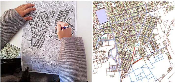
A child maps her route from home to school. The results are then digitized and aggregated to produce a digital and anonymized “heatmap” of the main routes to the school. (Photo by World Bank)
As part of these initiatives, students and parents were asked to map their routes to schools and modes of transportation, as well as hazards such as potholes or floods they had previously encountered. The aggregated data was then compiled and aggregated on municipality maps.
“The parents and children that participated helped the Municipality’s Department of Sustainable Mobility to visualize the actual risks related to school areas, with the aim of producing designs with high accessibility criteria, such as safer routes to/from schools, safer zones around schools, and minimized risk when approaching the school area on foot or by bicycle," according to Maria Zourna, Director of Sustainable Mobility Department at the City of Thessaloniki. "The Resilient Thessaloniki Office encouraged the participation of teachers, parents and children in the planning process, in order to bring the local community into an active role in the project.”
Data on historical earthquakes and floods was used to determine the number of people and buildings that would be impacted if these events were to happen again today. Quick impact modeling was done using open source software, known as InaSAFE, which demonstrated the benefit of having risk data openly accessible and applicable.
Projections indicate that an earthquake of the same M6.6 magnitude today would cause 4% of the city’s building stock to be damaged beyond repair, not to mention civilian injuries and casualties. A Risk Data Portal, now part of the digital services provided by the Municipality, also provides the public with detailed risk information on specific hazards, and already includes 119 geospatial datasets from 13 different organizations.
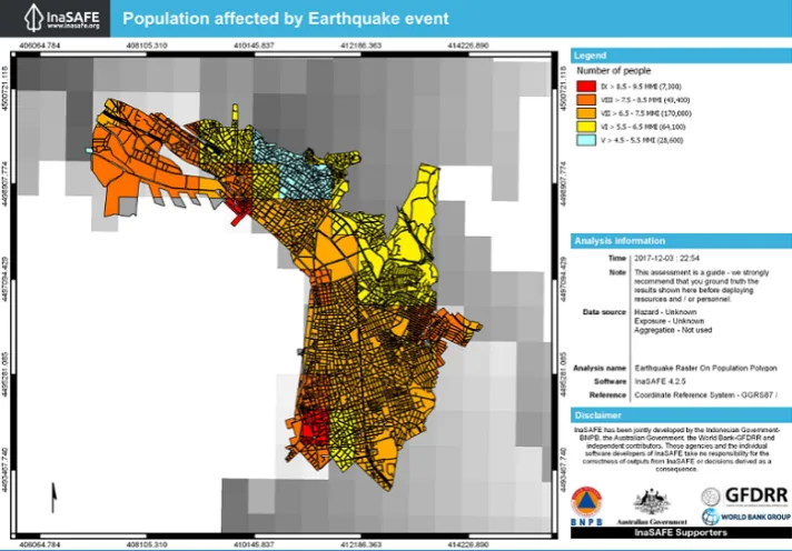
What would be the impact of the 1978 Earthquake on Thessaloniki today? The InaSAFE tool provides a glimpse of this scenario.
Risk data that is reliable and accessible has helped galvanize citizen-led efforts in Thessaloniki to prepare against natural disasters, which is amplified by outreach activities on behalf of the Municipality’s Resilience Office. For example, on the anniversary day of the 1978 earthquake, the Municipality invited several communities to share personal stories and insights about earthquake risk management and how they could cope with the aftermaths of the event.
By encouraging its citizens and local organizations to play a more proactive role, and by providing relevant information and data on climate and disaster risk, the Municipality of Thessaloniki is steadily moving towards a safer and more resilient future.