


Guyana: Strengthening Coastal Lands Information Systems and Adaptation Awareness
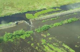
Historical East Demerara Water Conservancy dam breach
Context and Objectives
The project aimed to (i) strengthen Guyana's information systems on coastal lands; (ii) improve coordination among stakeholdersi; and (iii) implement a communications strategy for the World Bank-implemented Conservancy Adaptation Project (CAP).
Main Activities and Results
Specific activities included:
- LIDAR Data Management. An information storage and sharing system for the LIDAR study raw data was established, and Guyana's Lands & Surveys Commission's (GLSC) staff was trained to manage and share the LIDAR data.
- LIDAR Data Utilization: LIDAR data was integrated into GLGS Surveys Division to support topographic mapping, elevations, contouring, the identification of utilities as well as bathymetric modelling. GLSC’s Land Administration Division integrated LIDAR data into their systems for more efficient management of public lands.
- Coastal maps were updated to include demographic data and by village, in order to support faster response times during emergency situations.
- A communications strategy disseminated information on the CAP and convened stakeholders to support broader consensus on future adaptation investments
The following results were achieved:
- The project improved coordination among stakeholders within government and the donor community towards developing a comprehensive flood control strategy.
- The Ministry of Agriculture and the World Bank held a final workshop in March 2014 focusing on CAP results for the 2008-2013 period and on future investments under the 2013-2020 strategic plan. These included enhancing government knowledge and capacity to manage the East Demerara Water Conservancy and the coastal drainage systems, as well as a $123 million package of investments critical for flood management.
- A communications strategy ensured that policy-makers, stakeholders and the general public were fully informed of government and international interventions to respond to disasters and to prepare for potential catastrophic extreme rainfall events. The strategy also increased awareness of flood risk and disaster risk reduction needs.
- The project supported the publication of the CAP findings, Managing Flood Risk in Guyana, and the production of a video animation.
Partnerships and Coordination
This project was designed and implemented in coordination with existing initiatives being implemented by the IDB, JICA and EU.
Useful Links
The final report on the Conservancy Adaptation Project can be found here.
Country
Region
- Caribbean
Priority area
- Early warning systems and communication on DRR
Window of Action
- Window 2
Amount approved
- $250,646
Co-financing
- $0
Duration
- 09/2012 - 06/2014