Applications:
Countries
Completed: Kyrgyz Republic and Tajikistan
Being implemented: Peru
Sectors
Urban, DRM, Transport, Environment
Data requirement: Global data for purchase: Digital Surface Model with 0.5m or 2.5m resolution and satellite orthophoto with 0.5m resolution
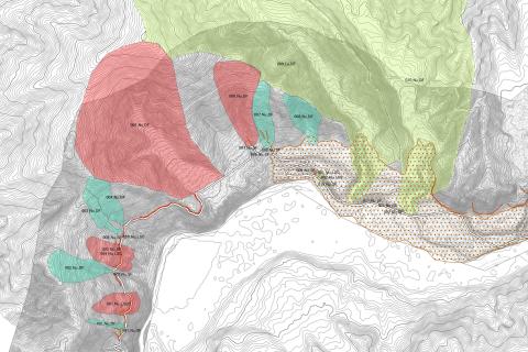
Final deliverables: Hazard maps, site inspection report, mitigation plan
Geographic scope: Customizable (e.g., City, Sub-basin, or Roads)
Hazards covered: Sediment-related disasters (landslides, mudflows, GLOFs, etc.)
Indicative cost/working time: US$10,000 for high-resolution data purchase
US$50,000 for consulting service including 1-2 week travel for site inspection & onsite capacity building workshop
Methodology peer-reviewed, cleared (date)? Numerous applications in Japan and globally with JICA projects (e.g., Bolivia, Bhutan, Kyrgyz Republic, North Macedonia, etc.)
A tool based on Japanese “chisan” / “sabo” techniques, which use an integrated nature-based solution (NBS)/hybrid solution to assess geohazards and plan mitigations measures for sediment-related disasters (landslides, mudflows, GLOFs, etc.) due to climate change and development pressure in hilly or mountainous areas.
Learn more:
Using High-Resolution Data to Screen Road Geohazards in Tajikistan
Nature-based solutions pilot by a Japanese company in the Kyrgyz Republic