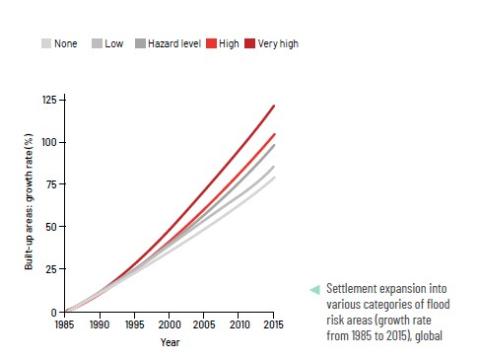
Description: Country or regional deep-dives documenting the evolution of the share of settlement extents that are
exposed to 1 in 100 year pluvial, fluvial and coastal floods from 1985 to 2015 (with extrapolation to 2020) at the Admin 0 and 1 level, per country income group and geography. The deep-dive provides a typology of recommendations and a series of visuals to understand the specific challenges of each administrative area. The analysis is based on high resolution global flood and settlement extent evolution data.
Sector: All
Sub-sector (if any): NA
Applications: Possible uses include inputs into ASAs, CCDRs, or early-day policy dialogues with clients.
Download the full document here.